Quito is an ideal destination for active tourism . Its altitude of 2,850 meters above sea level and its location as a base for exploring the Andean region, combined with the stunning geological diversity of its surroundings, make it a perfect base for exploring the Andean region. You don't have to travel far to find whitewater rivers, volcanoes, and hills ideal for hiking and trekking for all levels.
In this article, we'll review the distances, travel times, and routes to reach the Toachi River from Quito, the Quijos River, the Avenue of the Volcanoes, and other natural attractions near the capital. You'll also find itineraries for the most comprehensive excursions to help you plan your time, from hikes near Quito in the cloud forest of Mindo to high-altitude climbs in Cotopaxi National Park.
And if you want to travel with accommodation, transfers and tours already arranged , check out our Quito travel packages .
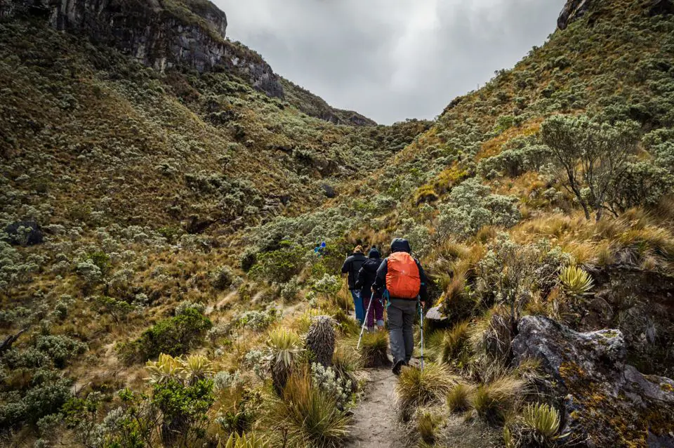
Hiking in Quito and surrounding areas
The topography of Ecuador's capital allows for hiking without having to stray too far from the city. However, due to the altitude, it's essential to dedicate the first few days of your trip to easy hikes. This will make it easier to acclimatize properly before attempting more challenging climbs.
Let's see what trails and paths await trekking enthusiasts in Quito.
Urban exploration and the Middle of the World
The best starting point is to explore the city's scenic viewpoints and its northern limits. The Middle of the World monument is located in the parish of San Antonio de Pichincha , 26 kilometers north of Quito's historic center. This journey takes about 45 minutes by car along Avenida Manuel Córdova Galarza.
The Quito Adventure and Middle of the World tour by panoramic bus includes transportation and a specialized guide. This full-day excursion begins with a ride on a double-decker bus through the historic center and to the El Panecillo viewpoint . Then, the tour travels north to visit the Middle of the World City complex, home to the monument marking the equator.
The excursion includes admission to the Intiñán Museum , where guides give demonstrations about magnetic forces at the equator, and ends with the return to the starting point in the city.
Hiking trail in the cloud forest of Mindo
If you're looking for hikes near Quito in a rainforest setting, the parish of Mindo is the perfect destination . It's located 90 kilometers northwest of the capital. The drive takes about two hours along Route E28 (via Calacalí - La Independencia), descending from Quito's 2,850 meters to Mindo's 1,250 meters.
He Mindo Tour: Adventure and Nature organizes a full-day tour to explore this biosphere reserve. You reach Mindo via the mountain road, and once there, you'll hike along the trails of the cloud forest and cross the Nambillo River via a handcrafted metal basket cable car to access the Waterfall Sanctuary.
The tour also includes a visit to a local butterfly garden and free time to enjoy a fresh trout lunch before heading back to the capital.
Where to go rafting in Quito: rivers and difficulty levels
Ecuador is one of South America's most renowned destinations for whitewater sports. Tour agencies use the capital as a hub and from there organize daily trips to the rivers that flow down from the Andes, both towards the Pacific and the Amazon .
The best rivers for rafting in Quito are the Toachi, the Blanco, and the Quijos . Let's see which tours take you rafting on them with all the necessary equipment and expert guides.
Rafting on the Toachi River from Quito
West of the capital, in the province of Santo Domingo de los Tsáchilas, flows one of the most popular rivers. The Toachi River is located 120 kilometers from Quito, in a The journey takes approximately three hours by car via Route E20 (Alóag - Santo Domingo). The rapids on this river are Class III and IV , ideal for both beginners and intermediate rafters.
The Toachi and Blanco River Rafting package from Quito handles all the logistics for this adventure. The excursion departs early from the city and includes round-trip transportation. Upon arrival at the riverside base, certified guides give a safety briefing and provide all the necessary equipment: helmet, life jacket, and paddle .
The rafting trip covers a 25-kilometer stretch through the river canyon, combining exhilarating rapids with calm pools for swimming . The day ends with lunch on the riverbank before returning to the city.
Descent down the Quijos River in the Amazon
If you're looking for a more challenging experience, rafting on the Quijos River is the perfect choice. This river hosted the World Rafting Championship in 2005 and offers technical Class IV and IV+ rapids. It's located in the Quijos Valley, about 100 kilometers east of Quito. The trip takes two hours via Route E20 towards Papallacta and Baeza.
The tour includes transportation from Quito, crossing the Andes Mountains and entering the high Amazon rainforest ecosystem . The descent down the Quijos rapids is uninterrupted, through dense vegetation and past waterfalls that plunge directly into the riverbed. The service includes professional rescue guides, safety equipment, and lunch at the end of the rafting trip.
Route of the volcanoes in Quito and the Ecuadorian Highlands
The Andes mountain range runs through the country from north to south, forming what the explorer Alexander von Humboldt named the "Avenue of the Volcanoes." Visiting the volcanoes in and around Quito requires knowing the altitudes and the condition of the access roads.
Cotopaxi National Park
Cotopaxi volcano rises to 5,897 meters above sea level, making it one of the highest active volcanoes in the world . The main entrance to Cotopaxi National Park is located 60 kilometers south of Quito, along the Pan-American Highway South (E35). The drive from the city center to the entrance checkpoint takes approximately an hour and a half.
Within the park, at an altitude of 3,800 meters, lies Limpiopungo Lagoon , a wetland that serves as a habitat for Andean birds such as the Andean gull and the Andean condor. From there, the road for vehicles ascends to the parking area located at 4,500 meters. At this point, a 45-minute hike can begin to the José Rivas Refuge , situated at an altitude of 4,864 meters, right at the edge of the permanent snow line.
The Quilotoa Lagoon
Further south and west, 170 kilometers from Quito, lies the Quilotoa Lagoon . The journey takes about three hours along the Pan-American Highway South, turning off at the city of Latacunga onto the Zumbahua circuit. Quilotoa is a volcanic caldera 3 kilometers in diameter , formed by the collapse of the volcano 800 years ago. Today, it is home to an emerald-green lagoon at 3,914 meters above sea level.
For an exclusive experience of this destination, the best option is the Quilotoa Lagoon tour . Departing from Quito, the tour stops at a viewpoint overlooking the Toachi River Canyon and then travels to the edge of the Quilotoa crater . From there, a 45-minute hike descends to the lagoon's shore. The return ascent is physically demanding due to the altitude, but the package includes the option of hiring mules from local community members for the climb. Lunch in the community and the return trip to Quito are also included.
Combined circuit: Cotopaxi and Quilotoa
If you're traveling with limited time and want to see both of these giants in a single day, the Cotopaxi and Quilotoa volcano tour is the perfect plan. This express tour departs very early from Quito. The first stop is at Cotopaxi National Park, where you'll visit Limpiopungo Lagoon and enjoy panoramic views of the perfectly shaped volcanic cone.
The journey continues south to the Quilotoa crater . Here there is time to walk along the upper viewpoints and photograph the lagoon before lunch and beginning the long drive back to Quito.